 | |||||||||


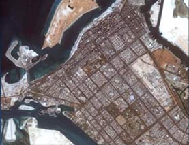
Imagery Exploitation and Analysis
The exploitation
and analysis system integrates commercially available software into
a tool to efficiently manage, process, exploit,
analyze and generate products from remotely sensed imagery data. Products are
generated using a variety of analytic techniques such as data fusion,
change detection, terrain analysis, and multi-spectral analysis.
The segment employs state-of-the art databases
to maintain imaging information on facilities, collection requirements,
databases reports and products. The database enable analysts to maintain
the historical information and conduct comparative analysis with newly
collected information.
To insure highest levels of security and confidentiality the different
elements are self-contained in the station. The segment comprises advanced
production capabilities, exploitation and analysis system, complex product
development for security operation, and rapid dissemination system for
information distribution among the armed forces. Imagery from a proven
reliable, rapid and secure system allows immediate access for decisions
makers. Commanders have in country access to imagery and information,
without delay and risk of compromise.